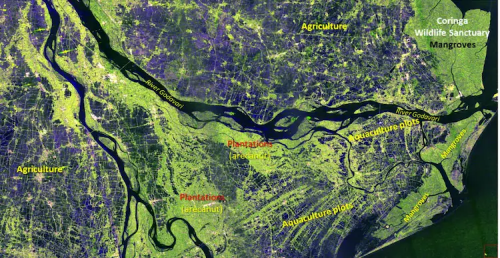
In a remarkable achievement for space and Earth observation technology, NISAR, the world’s most expensive radar satellite, has transmitted a breathtaking high-resolution image of India from orbit. The photograph focuses on the Godavari River Delta along India’s east coast, offering an unprecedented view of the region’s diverse landscapes.
The image highlights dense mangrove forests, vast agricultural fields, areca nut plantations, and extensive aquaculture ponds, all captured in exceptional detail. Scientists and environmentalists are particularly excited about the potential of this data to monitor ecological changes, manage natural resources, and track the health of coastal ecosystems.
Launched on July 30, 2025, NISAR represents a joint mission aimed at advanced Earth observation using synthetic aperture radar technology. Unlike optical satellites, NISAR can capture high-resolution images regardless of weather conditions or daylight, making it a powerful tool for research and disaster management.
Experts believe that insights from NISAR will revolutionize environmental monitoring, agricultural planning, and climate studies in India and around the globe. With its cutting-edge technology, NISAR is poised to become an indispensable resource for scientists, policy makers, and conservationists seeking real-time data on Earth’s changing landscapes.
This milestone underscores India’s growing participation in global space initiatives and marks a new era in satellite-based Earth observation. The detailed images of the Godavari Delta not only provide valuable scientific information but also showcase the natural beauty and ecological richness of the region from space.