The Manali-Leh Highway is a 490 km long road connecting Manali (Himachal Pradesh) to Leh (Ladakh). It is one of the highest motorable highways in the world, with an average elevation of over 4,000 m (13,123 ft).
Length: 490 km.
Highest Elevation: 5,328 m (17,480 ft) at Tanglang La Pass (Ladakh).
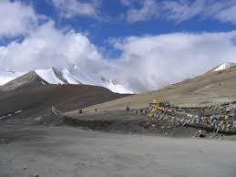
Major Passes Along the Route:
Rohtang Pass – 3,978 m (13,051 ft).
Baralacha La – 4,890 m (16,043 ft).
Lachulung La – 5,059 m (16,598 ft).
Tanglang La – 5,328 m (17,480 ft) (second-highest pass on the highway).
- Strategic Importance:
Crucial for Indian Army movements to Ladakh and border areas.
Acts as a lifeline for military supplies and local transport.
- Tourism & Adventure:
A popular route for bikers and adventure travelers.
Offers breathtaking landscapes of the Himalayas, valleys, and glaciers.
- Challenging Terrain & Weather:
Open only from June to October due to heavy snowfall in winter.
Landslides and extreme cold make travel challenging.
- Infrastructure Development:
Atal Tunnel (9.2 km) bypasses Rohtang Pass, reducing travel time.
Continuous BRO (Border Roads Organisation) maintenance ensures road connectivity.